
For Forest Managers overseeing expansive timberlands, a precise and up-to-date forest inventory is the cornerstone of strategic decision-making. Yet, traditional methods – often relying on time-intensive manual surveys and sample plots – are increasingly falling short. In an era demanding greater efficiency, sustainability, and adaptability, outdated or incomplete inventory data can become a significant operational bottleneck, impacting everything from harvest planning to long-term forest health and profitability.
The challenges are well-known: manual surveys are costly, labor-intensive, and inherently prone to sampling errors, especially across vast and varied terrains. The resulting data can quickly become obsolete, failing to capture dynamic changes like pest infestations, storm damage, or subtle growth variations. Large forest owners often make decisions with an incomplete picture, potentially leading to suboptimal resource allocation, missed opportunities, and increased risks.
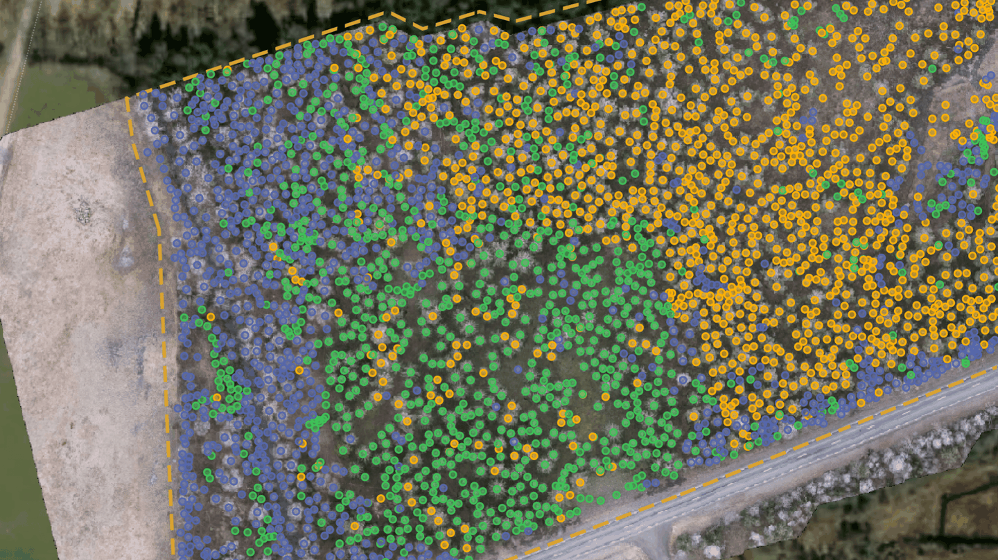
But what if you could access a near-real-time, tree-level understanding of your entire forest estate? This is no longer a futuristic vision, but a present-day reality powered by Artificial Intelligence (AI) and advanced remote sensing – a revolution that Arboair is spearheading.
The Shortcomings of Traditional Inventories: A Familiar Story
Forest Managers grapple daily with the limitations of conventional inventory practices:
These pain points directly impact a forest manager's ability to optimize operations, ensure sustainable practices, and maximize the value of their timber assets.
Arboair's AI-Powered Revolution: Seeing Your Forest with Unprecedented Clarity
Arboair is transforming forest inventory by leveraging the power of AI-driven analysis of high-resolution imagery captured by drones, aircraft, and satellites. Our sophisticated algorithms process this visual data to deliver previously unattainable insights, directly addressing the limitations of traditional methods.
The Arboair Advantage: Technology and Expertise Combined
Arboair's strength lies in our advanced AI models, continuously refined and validated. We utilize cutting-edge techniques, including the generation of synthetic forest data using game engines, to train our AI for unparalleled robustness across diverse forest types and conditions. Whether using drone imagery for ultra-high detail in specific areas or satellite data for cost-effective large-area monitoring, Arboair provides a scalable solution tailored to your needs. Our services extend to providing crucial GIS data layers, including detailed orthomosaics, digital elevation models, and specific analytics for thinning, clearing, plant survival, and felling optimization.
The result is a living, dynamic inventory accessible through ArboPortal, empowering Forest Managers to move from reactive to proactive management, backed by data they can trust.
Transform Your Forest Management with AI-Driven Inventory
The era of relying on infrequent, labor-intensive forest inventories is over. For large forest owners and their managers, embracing AI-powered solutions like Arboair's is key to unlocking new levels of efficiency, accuracy, and sustainability. Stop managing with estimates and start optimizing with precision.
Ready to see the future of forest inventory?