
Drone vs satellite for forest: which suits your property?
Imagine you own 3,000 hectares of forest in northern Dalarna. You know roughly where your spruce stands are, you have a management plan that was updated five years ago, and you have heard that the spruce bark beetle is moving north. Now you are wondering whether you should get an updated picture of what is actually happening in your forest — and you have started reading about drones and satellites without becoming much the wiser.
It is a situation that has become more common as airborne data collection has become more accessible. And the question most people ask — drone or satellite? — is really the wrong question. The right question is: what do you need to know, and how certain do you need to be?
Guessing or knowing — that is what the choice is really about
Jacob Hjalmarsson, co-founder and CTO at Arboair, tends not to answer directly when someone asks him which technology they should use. He asks a question back: what are you going to use the result for?
The answer to that question determines everything else, because the two technologies are fundamentally different in what they can deliver. Satellite is cheap and covers enormous areas quickly — but it gives you estimates. Drones are more expensive and require more planning — but they give you facts.
That is not a value judgement. Estimates are excellent when you need a starting point. You do not need to know exactly which trees are attacked by bark beetle if you only want to work out which of your three forest areas you should prioritise for further investigation. But once you are going to act — when you have to make a financial decision, plan a harvest, or sell a property — estimates are not enough.
Why satellite resolution sets the ceiling on what it can see
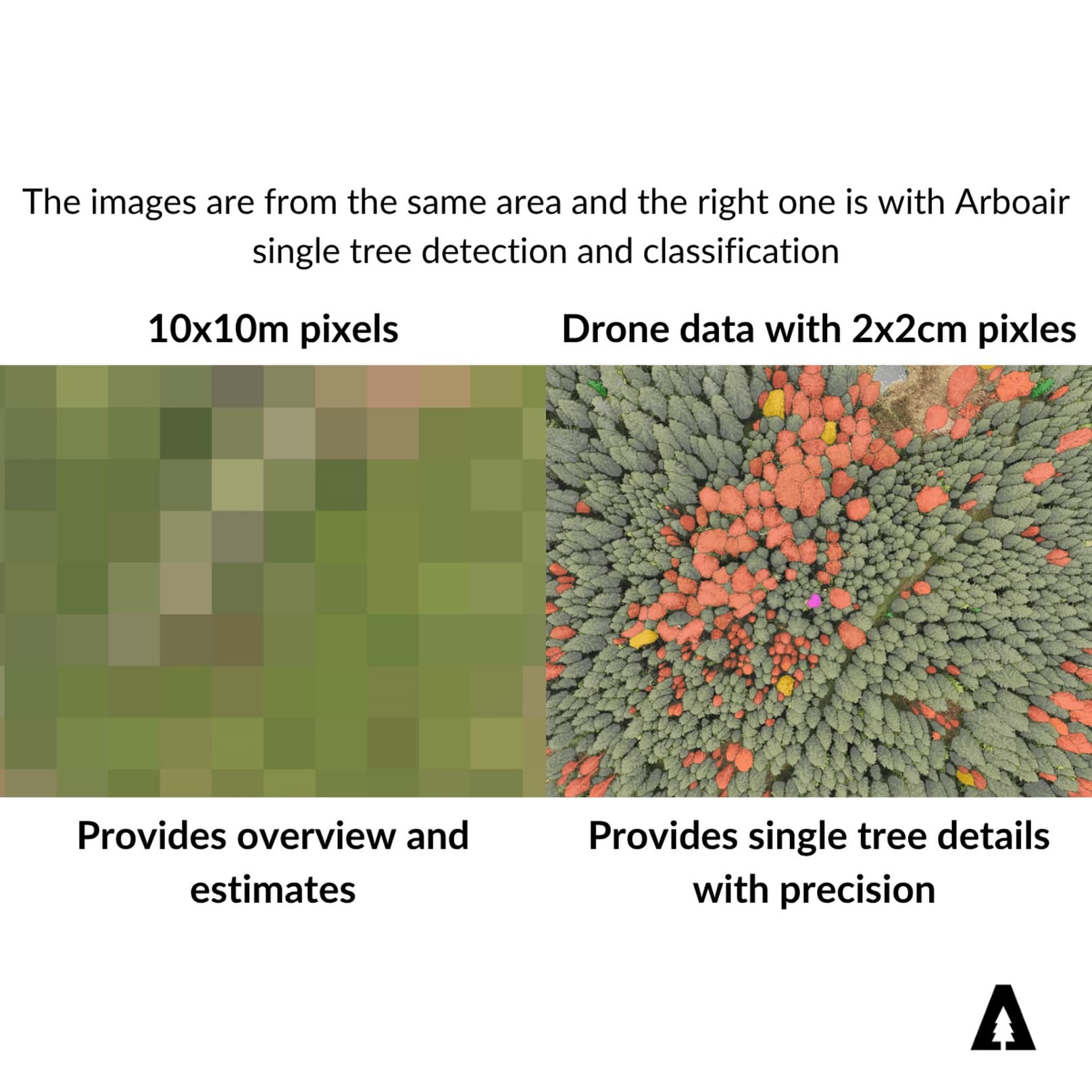
The best commercially available satellite imagery today has a resolution of 15 centimetres per pixel. That sounds precise, but the reality is more complicated. That image is AI-processed from 30-centimetre data — the original image has been treated with so-called super resolution, a technique that interpolates sharpness which does not really exist in the sensor. The best raw material the satellite actually captures is therefore 30 centimetres per pixel.
Thirty centimetres per pixel is a hundred times lower resolution than a drone image.
That figure can be hard to grasp intuitively, but it shows clearly in the results. In image analysis the rule of thumb is that you need at least ten by ten pixels on an object to identify it with reasonable confidence. With 30-centimetre pixels, that means the smallest object you can see clearly is roughly nine square metres. Most fully grown trees with visible, extensive damage fit within that. But a tree that is only partially attacked often falls below that threshold. A windthrown tree partly obscured by standing trees may show up as an irregularity in the canopy but not as a harvestable volume. And a healthy tree that happens to be in the shadow of its neighbour — depending on the sun angle when the image was taken — can look like a black patch in the satellite image rather than a living tree.
To that must be added the atmospheric interference always present in satellite data, and the risk of cloud making the entire image unusable.
There is also a structural limitation rarely mentioned in the marketing: satellite images are two-dimensional. They capture the surface, but they provide no information about height or three-dimensional structure. Height information must instead be sourced elsewhere — in Sweden the open laser data from the national mapping agency is often used — and combining several data sources, each with its own margin of error, introduces uncertainties that compound rather than cancel out.
It is nonetheless precisely that combination which has made satellite-based estimates useful. Companies such as Collective Crunch and TerraLabs have shown that it is possible to build estimation products that perform better than SLU's Skogliga Grunddata — the system most automatic forest management plans are built on today — by combining satellite imagery, historical measurements and advanced machine learning models. But they are still estimates. Better estimates, but estimates.
What drone vs satellite delivers in damage inventory
The practical consequence of the resolution difference shows most clearly in damage inventories. When Arboair supplements a satellite-based damage assessment with drone flights, the drone data consistently finds more than 40 per cent more damage.
That is not a small error. It is the difference between believing you have a manageable problem and realising you have a serious one. For a forest owner working through their finances, planning their extractions or negotiating with an insurance company, that difference can be decisive.
The damage types satellite handles relatively well are large-scale, contiguous damage — the stands flattened by a storm that look like brown patches in the green. That is exactly the damage visible in the Swedish Forest Agency's satellite-based risk maps for spruce bark beetle and windthrow, and it is a genuinely useful function. But individual attacked trees, scattered windthrow and early bark beetle attacks — the things that determine whether damage spreads or stops — require drone resolution.
The cost of knowing
A mid-resolution satellite image covering 2,500 hectares costs between SEK 10,000 and 15,000. Lower resolution can cost half that. The Forest Agency's maps are free.
A drone flight over the same area takes five to eight working days with a professional pilot. The pilot cost is SEK 650 to 1,250 per hour depending on equipment and operator — a total in the order of SEK 30,000 upwards for the flight, before image processing and analysis are counted.
That is a large difference in absolute terms. But it is also the wrong way to compare them.
The satellite's cost gives you something to navigate by. The drone's cost gives you decision support you can act on without hesitation. In a property transaction, a generational transfer or a damaged forest, the difference in factual value can far exceed the difference in data collection cost. A forest owner who sells a stand based on a five-year-old management plan and a satellite estimate often leaves money on the table that a drone-based analysis could have made visible.
Weather, seasons and why satellite is not always available
Satellites orbit the earth every day, but that does not guarantee access to usable imagery. In the northern Nordics the period from November to February is practically unusable for new image capture — the combination of persistent cloud cover and low sun angle makes the raw material substandard. The best conditions are found from April to September.
That is why most commercial estimation products are based on historical data. Suppliers know customers cannot wait for a high-pressure window in November, and instead build their products on archive imagery from recent seasons. That provides availability — but at the cost of currency.
Drones are stopped by rain and strong wind, but they are not bound by sun angle or season. During a high-pressure spell in February it is possible to fly and collect data the satellite can never deliver from the same period in northern Sweden. That operational flexibility is an underrated advantage — particularly when damage or a business opportunity does not fit into the summer season.
How large forest holdings should think about the two technologies
For anyone managing tens of thousands of hectares, the answer is not to choose one technology and exclude the other. The rational setup looks roughly like this.
The foundation of the management plan — the basis on which cash flow analyses, action plans and investment decisions rest — is best built on drone data. That gives a factual base that holds over time. Satellite-based services then take over for ongoing monitoring: they identify hotspots, flag anomalous patterns and help the manager prioritise where resources should go. When a satellite map points out a risk area, the drone is sent there to confirm what it actually is, quantify the damage and provide the basis for a concrete decision.
Satellite to prioritise, drone to act.
Arboair offers both tracks. As a Solutions Partner to EUSI, satellite imagery is analysed for large-scale damage mapping across large holdings at a lower cost — an entry point that helps forest owners get a quick picture of where the problems are. Drone analysis via ArboPortal takes over when it is time to know.
The technology changes, but the principle holds
It is tempting to assume that better satellites will eventually solve the resolution problem and make drone data redundant. But the quality of satellite imagery is limited not only by what engineers can build — it is limited by regulation and geopolitics. International agreements govern how close to the earth's surface commercial satellites may orbit, and those discussions do not move at the pace of technology. The fundamental principle — that a sensor hundreds of kilometres up in the atmosphere sees the world differently from a camera at 120 metres — is likely to hold for a long time yet.
The drone operates a few hundred metres up. It sees the tree, not the stand.
Back to the forest owner in Dalarna with their 3,000 hectares and their concern about bark beetle: the smartest first step is to use the satellite-based maps already available to get a rough picture of where the risk is greatest. Then fly those stands with a drone. Not because satellite is bad — but because guesses are a good way to decide where to look, and facts are the only way to decide what to do.
Create an overview first. Prioritise which actions matter. Fly them with a drone — to know that you have the right information, are taking the right decision and are getting paid the right amount.